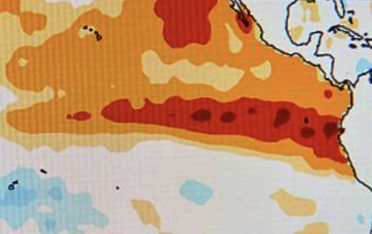
Somewhere beneath the surface of the equatorial Pacific, a massive pulse of warm water has been building for months. Climate scientists first flagged it as a modest possibility earlier this year. By mid-2026, that possibility had turned into one of the strongest forecast signals in decades: a “Super” El Niño, with a real chance of becoming the strongest event ever recorded.
If you’ve seen headlines swinging between “record-breaking” and “historic,” you’re not imagining it — the forecast has moved quickly, and for good reason. Here’s what a Super El Niño actually is, what forecasters expect through winter 2026-2027, and what it could mean depending on where you live.
What Is El Niño, Exactly?
El Niño is the warm phase of a natural Pacific Ocean cycle called ENSO (El Niño-Southern Oscillation). Every few years, the ocean surface in the central and eastern tropical Pacific warms above average, shifting rainfall patterns, reshaping the jet stream, and altering weather across the globe — sometimes for a full year or more.
A “Super” El Niño is simply the strongest tier of this event, officially recognized when sea surface temperature anomalies sustain at least +2.0°C above the long-term average. It’s a rare classification. Only a handful of Super El Niño events have been recorded since reliable measurements began, including 1982-83, 1997-98, and 2015-16 — each one associated with major global weather disruption.
Why 2026 Looks Different
Forecast agencies including NOAA, ECMWF, and Australia’s Bureau of Meteorology have converged on unusually high confidence for this event. NOAA’s Climate Prediction Center has put the odds of at least a strong El Niño by autumn or early winter above 85%, with a meaningful chance of the event crossing into “very strong” or Super territory.
Two things are driving the unusually strong signal:
- An intense subsurface Kelvin wave. Warm water has been building well below the ocean surface since early 2026, acting like stored energy waiting to surface and reorganize atmospheric pressure patterns.
- A warmer baseline ocean. Because global ocean temperatures are already running higher than in past decades, scientists note that even a “typical” strong El Niño now carries more energy to release into the atmosphere than the same event would have a generation ago.
Forecasters are cautious about locking in the exact peak strength this early — spring forecasts for ENSO carry more uncertainty than forecasts made later in the year — but the trend across multiple independent models has remained consistent: this event is expected to peak sometime in late fall or early winter 2026.
What a Super El Niño Could Mean, Region by Region
El Niño doesn’t affect the whole planet the same way. It tends to reshuffle where rain and dry air go, rather than simply making everything warmer or wetter.
United States: Past Super El Niño winters have brought a wetter, stormier pattern to the southern U.S. and a milder, drier pattern to the northern tier. Frequent storm system alerts and heavier rainfall are common outcomes for states along the Gulf Coast and Southern California during a strong event.
Atlantic hurricane season: El Niño typically increases wind shear across the Atlantic, which can suppress storm formation later in hurricane season — a rare silver lining for coastal communities monitoring hurricane warnings each summer and fall.
Southeast Asia and Indonesia: El Niño years are historically associated with reduced rainfall and delayed monsoon onset across Indonesia and much of Southeast Asia, raising drought and wildfire risk. Understanding local rainfall patterns and how they connect to broader climate cycles is especially useful for households and farmers trying to plan around a drier season.
Australia: Strong El Niño events have previously coincided with hotter, drier conditions and elevated bushfire risk, particularly across the country’s southeast.
South America: Coastal Peru and Ecuador, closest to the warm-water source itself, have historically seen the heaviest flooding impacts during past Super El Niño events.
It’s worth noting that El Niño shifts the odds of certain weather patterns — it doesn’t guarantee any single outcome for any single place. Local forecasts closer to the season will always be more reliable than the broad seasonal outlook.
How to Prepare, Wherever You Are
You don’t need to overhaul your life around a seasonal forecast, but a few sensible steps go a long way if your region has a history of El Niño-linked extremes:
- Check your area’s typical El Niño pattern. A quick look at how your region behaved during 2015-16 or 1997-98 gives a reasonable (though not guaranteed) preview of this year.
- Review your emergency basics early. If you’re in a flood-prone area, this is a good season to double-check drainage, gutters, and emergency supplies well before storm season peaks — a quick read through general flash flood safety guidance is a sensible place to start.
- Farmers and gardeners should plan for variability. Both unusually wet and unusually dry outcomes are on the table depending on region, so flexible planting and irrigation planning matters more than usual this year.
- Travelers should build in flexibility. If you have travel planned to a region with a strong El Niño signal, keep an eye on seasonal outlooks as the date approaches rather than relying solely on historical averages.
The Bigger Picture
Whether or not 2026 ultimately breaks the all-time record, the forecast itself is a reminder of how interconnected global weather really is. A warm-water pulse forming thousands of miles offshore in the Pacific can reshape rainfall in Jakarta, hurricane risk in the Gulf, and wildfire conditions in Australia, all in the same season.
The good news is that El Niño, unlike many extreme weather events, is forecast months in advance. That lead time is exactly what makes preparation possible — for governments issuing early warnings, and for households making small, sensible adjustments before the pattern fully arrives.
FAQs
Q1: What makes an El Niño “Super”?
A Super El Niño is declared when sea surface temperature anomalies in the tropical Pacific sustain at least +2.0°C above the long-term average — a rare, top-tier classification that only a handful of events have reached since reliable records began.
Q2: When will the 2026 El Niño peak?
Forecasters expect the event to peak in late fall or early winter 2026, which is the typical timing for ENSO events, though the exact peak strength remains uncertain this far out.
Q3: Does El Niño mean more hurricanes?
Generally the opposite for the Atlantic — El Niño tends to increase wind shear, which can suppress storm formation later in hurricane season, though regional exceptions exist.
Q4: How does El Niño affect Indonesia?
El Niño years are typically linked to reduced rainfall and delayed monsoon onset across Indonesia, which raises the risk of drought and wildfires in affected regions.
Q5: Is a Super El Niño caused by climate change?
El Niño is a natural ocean-atmosphere cycle, not something climate change creates. However, scientists note that a warmer baseline ocean can make even a typical strong event carry more energy and potentially larger impacts than the same event would have decades ago.