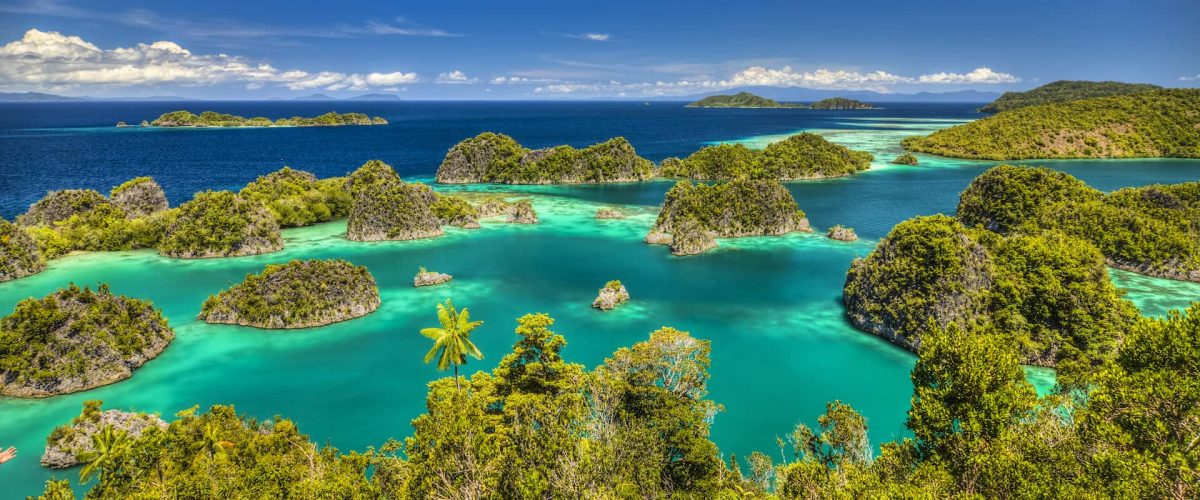
The Raja Ampat Islands comprise a cluster of four main islands adjacent to the western part of Papua’s Bird’s Head Peninsula (Vogelkop). Located within the Raja Ampat Regency of West Papua Province, the largest islands are Waigeo, Misool, Salawati, and Batanta.
Renowned for their marine tourism potential, Raja Ampat is celebrated for its breathtaking underwater scenery, making it a premier destination for divers. Its waters rank among the top 10 best diving spots in the world, and many consider it the number one location for marine biodiversity. According to Dr. John Veron, a renowned Australian coral expert, Raja Ampat boasts Indonesia’s richest coral ecosystems, with approximately 450 coral species.
Several reef areas remain in pristine condition, with live coral coverage reaching up to 90%, particularly in the Dampier Strait (between Waigeo and Batanta), the Kofiau Islands, the Southeast Misool Islands, and the Wayag Islands. The reefs primarily consist of fringing reefs with steep slopes, though atolls and patch reefs (taka) are also present.
A unique phenomenon occurs in Kampung Saondarek, where coral reefs are exposed during low tide. Remarkably, these corals survive despite being out of water and exposed to direct sunlight.
Beyond its natural wonders, Raja Ampat holds historical and archaeological significance. The Misool cluster features prehistoric cave art, including ancient hand stencils on rock walls near the sea surface. Estimated to be 50,000 years old, these artifacts provide insight into early human migration from western Indonesia to Papua and Melanesia. Additionally, several dive sites, such as Wai Island, contain World War II shipwrecks, adding to the region’s allure.
Administrative Overview of Raja Ampat Islands
The Raja Ampat Islands span a total area of 46,108 km² and are administratively divided into 24 districts, which include 117 villages and 4 urban villages (kelurahan). The districts are as follows:
- North Misool District
- North Waigeo District
- South Waigeo
- North Salawati District
- Ayau Islands District
- East Misool District
- West Waigeo District, Mainland
- East Waigeo District
- Mayalibit Bay District
- Kofiau District
- Meosmanswar District
- South Batanta District
- South Misool District
- Wawarboni District
- West Waige Islands District
- West Misool District
- District of Sembilan Nine
- Wasai City District
- Salawati Tengah District
- Salawati Barat District
- Ayau District
- Tiplol Mayalibit District
- North Batanta District
- Supnin District
Travel Tips to Raja Ampat: History & Mythology
The Legend of Raja Ampat’s Origins
According to local folklore, the name Raja Ampat (meaning “Four Kings”) originates from a myth about a woman who discovered seven eggs. Four of these eggs hatched into princes, who became the rulers of Waigeo, Salawati, East Misool, and West Misool—thus giving rise to the “Four Kings” of the archipelago. The remaining three eggs transformed into a ghost, a woman, and a stone, embedding mysticism into the region’s cultural heritage.
Read: Bali Nusa Penida or Ubud
Historical Governance
In pre-colonial times, the Raja Ampat Islands were governed by a system of aristocracy influenced by Maluku traditions. Society was organized into kinship groups, with each village led by a local king (raja).
During the colonial era, the islands were incorporated into the Dutch East Indies after Dutch forces took control. This marked a shift in governance, though many indigenous customs persisted.
Today, remnants of this regal past can still be seen in the cultural traditions of Raja Ampat’s communities.
Travel Tips to Raja Ampat: How to Get There
Raja Ampat is accessible by both air and sea, offering options for different budgets and travel preferences.
1. By Air (Fastest Option)
Although located in West Papua, Raja Ampat is well-connected by flights to Sorong, the gateway city to the islands.
- From Jakarta/Bali to Sorong:
- Via Manado: Lion Air or Wings Air (4 hours total, including stopover).
- Via Makassar: Garuda Indonesia or Sriwijaya Air (6 hours total).
- Direct: Express Air offers a non-stop 4-hour flight from Jakarta to Sorong.
- From Sorong to Raja Ampat:
- Take a small charter flight with Susi Air (14-seater) to Waisai.
- Alternatively, continue by boat (see below).
Sorong is a well-equipped city with adequate facilities, making it a convenient stop before heading to the islands.
2. By Sea (Budget-Friendly Option)
After arriving in Sorong, you can reach Raja Ampat by boat:
- Ferry Options:
- Pioneer Ships, Tourist Ships, or ASDP Ferries operate on the Sorong-Saonek/Waisai route.
- Departure Schedule:
- Sorong → Waisai: Departs at 1:00 PM (1.5–2 hours travel time).
- Waisai → Sorong: Departs at 11:00 AM (West Indonesia Time).
- Ticket Purchase: Contact the Raja Ampat Culture and Tourism Office at (0411) 402650.
Read: Holiday Travel Tips to Borobudur Temple
3. Exploring the Islands
Once in Raja Ampat, you can:
- Rent a private boat or join a pinisi tour for island hopping.
- Stay at resorts like Raja Ampat Dive Lodge, which caters to both divers and non-divers.
Why Visit? Beyond diving, Raja Ampat offers:
- Pristine white-sand beaches.
- Stunning karst island formations.
- Unique wildlife, including:
- Birds-of-paradise (Red Cendrawasih, Wilson’s Bird-of-Paradise).
- Waigeo maleo, parrots, cockatoos.
- Waigeo cuscus and rare orchids.
Travel Tips to Raja Ampat: Transportation
The most common way to explore Raja Ampat is through tours arranged by travel agents in Sorong. These typically include island-hopping boat tours and diving packages. Here are your transportation options:
Boat Options from Sorong:
- Speed Boats
- Capacity: 15 passengers
- Travel time: 1 hour 40 minutes to Waisai
- Approximate cost: IDR 2,000,000 (prices subject to change)
- Long Boats (Traditional Wooden Boats)
- Capacity: 10 passengers
- Travel time: 2-3 hours to Waisai
- Approximate cost: IDR 1,200,000 (prices subject to change)
For More Flexible Exploration:
- Consider renting a private small boat to create your own island-hopping itinerary
- The archipelago consists of:
- 4 main mountainous islands (Waigeo, Batanta, Salawati, and Misool)
- Hundreds of smaller islands and islets
Tips:
- Boat prices fluctuate, so confirm costs when booking
- Morning departures are recommended for calmer seas
- Pack light as storage space on boats may be limited
For the most current schedules and pricing, consult with local travel agencies in Sorong before your trip.
Travel Tips to Raja Ampat: Hotels
The following are recommendations for lodging and hotels in Raja Ampat that you can use to stay while you are there:

Fundar Sakela Road, Lukas Delon Street, Raja Ampat, Indonesia, 98481

Trans Wisata No. 88, after Marinda Airport, Saleo Beach, Waisai, Raja Ampat, Raja Ampat, Indonesia, 98482
- Raja Ampat Diva Homestay, yenbeser village, besir, raja ampat, west papua, Raja Ampat, Indonesia, 98482

Jalan Arfan, Raja Ampat, Indonesia
- Rifalda Cottage, Jl. Yos Sudarso – Kimindores, Raja Ampat, Indonesia, 98482

- Saleo Beach, Raja Ampat, West Papua, Raja Ampat, Indonesia, 98482
- Cockatoo Hostel, Jalan Yos Sudarso no 8, Raja Ampat, Indonesia, 98482

Friwen Island, Raja Ampat, West Papua 98482, Indonesia, Raja Ampat, Indonesia, 98482
- Mawar Homestay, Arborek Island, Raja Ampat, Indonesia, 98482
Jl. Saporkren No 3 Rt.001 Rw 001, Raja Ampat, Waigeo Selatan, Waisai, Raja Ampat, Indonesia, 98482
- Best Raja Ampat Cottage, Sauandarek Island, Raja Ampat, West Papua, Indonesia, Raja Ampat, Indonesia, 98482
- Nut Tonton Homestay, Kampung Usaha Jaya, East Misool District, Raja Ampat Regency, West Papua., Raja Ampat, Indonesia, 98483

Pam Island, Raja Ampat, Indonesia, 98481
- Phuyaka Mengge, Funder Sakela Road, Waisai, Raja Ampat, Indonesia

Jalan Kimindores, Waisai, Raja Ampat, Indonesia

Yenmangkwang Beach, Waigeo Island, 98482 Tapokreng, Raja Ampat, Indonesia
West Waigeo, Selpele Village, Raja Ampat, Indonesia

Jalan Marinda, Waiwo, Raja Ampat, Indonesia

Jl. Trikora No 21 Saonek, South Waigeo Raja Ampat Regency – West Papua, Raja Ampat, Indonesia, 98482
Travel Tips to Raja Ampat: Climate
The Raja Ampat Islands have a humid and hot tropical island climate. Generally, sunny weather with blue or cloudy white skies lasts most of the year. The average temperature is 27.4 0C with rainfall of 2,000 mm / year, where the dry and rainy seasons are not as clear as Papua in general.
Regional Languages in Raja Ampat
Generally, residents use the language of Papua as an everyday language. However, they can also use Indonesian as a communication with tourists, so you don’t have to worry about communicating with the local community.
Read: Indonesian Visa for US Citizen
Travel Tips to Raja Ampat: Tourist Attractions
There are many tourist attractions in Raja Ampat that can be visited. Some of them are as follows:
- Waiwo Beach
- Waisal Beach
- West Waigeo Island Nature Reserve
- West Batanta Island Nature Reserve
- North Salawati Island Nature Reserve
- South Misool Island Nature Reserve
- Arborek Tourism Village
- Sawinggrai Tourism Village
- Yenwaupnor Tourism Village
- Sauwundarek Tourism Village
Malls in Raja Ampat
Unlike other tourist cities in Indonesia, the Raja Ampat Islands do not have large malls or shopping, but have souvenir shops in various regions. For example, Arborek Village is famous for woven crafts that you can buy. Other souvenirs that you can bring home are Asmat statues, traditional fabrics and traditional musical instruments Suling Tambur (traditional drums).
Read: Travel with Medication to Indonesia
Travel Tips to Raja Ampat: Culinary
Various stands at the Raja Ampat Anniversary Celebration
- Culinary at the Raja Ampat Festival
- Yellow Fish Soup on the coast of West Papua Beach
- Sago Caterpillar Satay
- Papeda
- Sea Fried Worms
Travel Tips to Raja Ampat: Summary
Some of these tourist tips in Raja Ampat will be useful for those of you who want to vacation in Raja Ampat:
1. Make a Plan with Ripe
Plan your trip especially about lodging and transportation because these two things are important and expensive if you are not careful. Preferably, look for standard lodging that is cheap, close and complete with prices ranging from IDR 200,000 per night. Another alternative is to stay in a resident’s house for rent to be cheaper. As for transportation, try to find promo flight tickets to Sorong or use the Pelni Ship from Tanjung Priok Port in Jakarta to Sorong at a cost of Rp. 700,000 to Rp. 800,000 with a five-day four-night trip. Even to get to Raja Ampat, use a boat to save more money.
2. Report to the Department of Culture and Tourism in Waisai
The mandatory thing to do when you arrive at Waisai is to report to the Department of culture and tourism by paying a conservation fee of IDR 250,000 for local tourists and IDR 500,000 for foreign tourists.
Read: Ascott Hotel Kuningan Jakarta
3. Take a trip with a group
This is done to save money. If you travel with a group, the previously expensive fees can be shared with other group members.